Disaster Resilience
Evaluation of Loss Estimates For Hurricane Iniki; Kauai
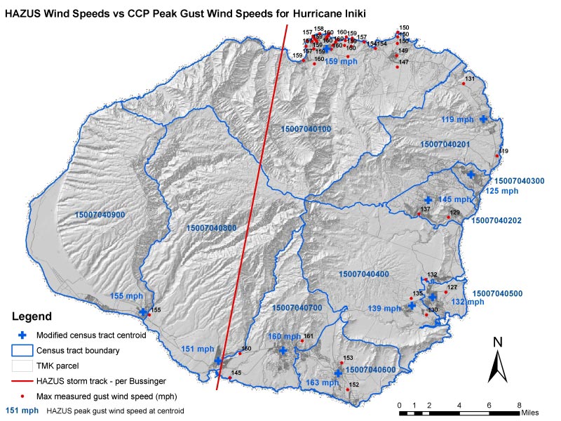
HAZUS MH includes a hurricane loss estimation module. However, there was no published validation of the model for Hawaii hurricane losses. Martin & Chock performed a case study to provide a validation assessment. A Hurricane Iniki scenario case study was conducted of HAZUS MH versus an existing series of parcel-geocoded reconstruction cost databases for each community on Kaua‘i Past information on Hurricane Iniki damage to Hawaii buildings of residential, commercial, and resort occupancies were gathered and geo-referenced on GIS. Derived from original damage and reconstruction data collected by the FEMA-sponsored Office of Emergency Permitting, the processed loss cost database is a very detailed property-geocoded database of Iniki losses for building structures on private property across the entire island of Kaua‘i. It includes damage states, damage type, reconstruction cost, and reconstruction duration, and comprehensive reconstruction material and specific building type attributes, year built or altered, and property valuation, building size, height, configuration, etc. This included indigenous Hawaii construction features. The property tax database was used in conjunction with geocoded parcels in GIS to create 1992 equivalent census tract occupancy mapping schemes for general building stock in HAZUS MH. By these means, HAZUS MH results for Hurricane Iniki were compared to actual damage date for equivalent building inventory representations.
WORK WITH US
CALL (808) 521-4513
1001 Bishop Street,
Suite 2950, Honolulu,
HI 96813